Navigate Kuala Lumpur Roads Like a Pro – Essential Guide
Driving in Kuala Lumpur can be both exciting and frustrating. Between traffic jams, sudden forks in the road, and the occasional disappearing road sign, even seasoned KL drivers can get thrown off course. While GPS apps like Waze and Google Maps make life easier, knowing how to navigate KL without technology is a valuable skill — especially if your phone battery dies or your signal drops.
In this ultimate guide, we’ll walk you through the essentials of navigating Kuala Lumpur’s roads confidently, reading road signs effectively, and making smart driving decisions in tricky situations.
by TheLorry on 13 August 2025.
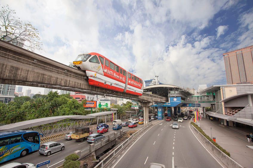
Driving is becoming more and more of a hassle nowadays as traffic jams continue to irk our daily lives. Despite living in a city with such a diversed names for roads , none can be more frustrating than getting lost when driving, especially considering how weird our road signs can be.
Now before you turn this away because you know you can Waze or Google Maps your way to virtually anywhere in anyway possible, maybe you’d like to know how to navigate the road by following the road signs the next time your GPS might be out of order.
The Reality of Driving in KL
KL’s roads are a labyrinth. You can start a trip following a clear “KLCC” sign, only to find it suddenly missing at the next fork. This isn’t an accident — road signage in Malaysia often assumes you already know the general direction. The key is learning to read context clues, like nearby destinations and exit numbers, to stay on track.
Example: If your goal is KLCC and your last sign listed it alongside “Jalan Duta” and “Petaling Jaya,” stick to that path until you see your destination again, even if it temporarily disappears from the signs.
Why Road Signs Disappear (and How to Handle It)
One common frustration is the “disappearing act” — when your destination suddenly vanishes from signboards. This happens because road signs prioritize major junctions and broader areas first.
Quick tips when this happens:
-
Stay calm and keep driving forward if your last sign suggested you were still on the right path.
-
Look for related destinations that were listed alongside yours earlier.
-
Avoid sudden exits unless you are sure they lead toward your destination.
The disappearing act
Let’s paint a picture of the problem. Say you want to go to Kuala Lumpur’s main attraction, the Petronas Twin Towers. And for whatever reason you can’t use your phone or car’s GPS, leaving you to depend fully on the signs for direction.
I know, a very scary situation to be in, given how spoilt we have become in this technological and wondrous age.
Anyways, so you don’t have your GPS, and you have to follow the road signs to get to KLCC. It’d be safe to say that you would be on the right track to follow a sign that spells out ‘KLCC’, obviously.
But is it that simple? Actually…not so much. Because you would then be challenged by a fork in the road, with the signs pointing nowhere to the twin towers.
A lot of people will at this point panic, and will be in a state of confusion, anger, or disbelief. And I am talking from experience here.
How can this be? you might ask yourself. Why would you just suddenly not tell me where my destination is, especially when there’s multiple forks I could be taking now? Oh cruel road signs, how you mock me.
So what can you do during this situation? Which road should you be taking if none of the signs are showing where you want to go, even though it had previously? What can you do if you’re facing the road signs’ disappearing act?
Stay on your route
Here’s a tip, your destination will always be an exit from the road you’re driving on. Oh and please give extra attention to the other destinations usually listed together with yours.
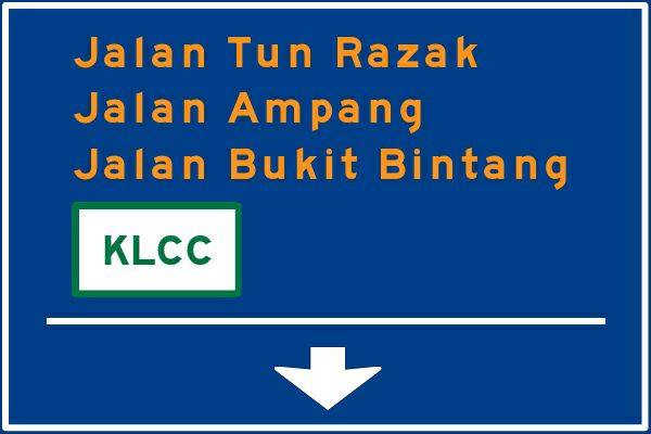
Here’s a visualisation to help you out, with the red being your destination. (Signs showed are not accurate, but merely a representation)
First sign;
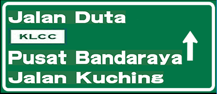
Easy enough, just follow this sign and drive along the road.
Then further up the road, you’ll be at a fork, with two signs;
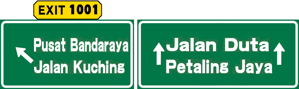
This is where a lot of people can get confused, because KLCC suddenly disappears without a trace, and now the road starts to diverge into two separate roads.
Don’t panic! Because remember, the sign before this one showed that KLCC is up ahead, and seeing as ‘EXIT 1001’ doesn’t say KLCC, you shouldn’t be taking that exit. You should continue on towards Jalan Duta and Petaling Jaya, because you will most likely find the right exit farther up the road.
What To Do When You’re Lost
Missing an exit in KL isn’t the end of the world. Here’s how to recover quickly:
-
Look for U-turn signs – the fastest way to correct your route.
-
Head toward a nearby landmark – even if it’s not your exact destination, you can recalibrate from there.
-
Stay alert for your destination to reappear – road signs often bring it back into view after a few junctions.
I’m totally lost, now what?
In the likelihood that you have missed your exit, or have taken the wrong one by mistake, first thing you should do is to slow your roll. Reduce your speed and try to regroup your thought. Start looking out for all the signs which could point you in the right direction.
Firstly, look out for any U-turn signs, which would be the fastest way to get back on track.
If there is no U-turn in sight, try to find the way towards a place close to your destination. This is why you should give extra attention to the other destinations usually listed together with where you want to go.
If the destination you were driving towards had Pusat Bandaraya also listed with it, it would probably be smart to look for Pusat Bandaraya again when you’re lost.
There is also a chance that you may not be as lost as you think, as a sign that points to your destination could pop up again even when you’ve screwed up the first time.
👉 Chat with us on WhatsApp – We’re here to help with transport solutions across KL and beyond.
Colourful directions
As you have surely noticed as a driver, the places and roads shown on our road signs can be in different colours. Why, you asked? Because it signifies the different type of destinations, routes, and roads.
Tourist attractions such as aforementioned KLCC and some other places are usually visualised by road signs in white with green lettering. Other tourist attractions may also be seen with directions in brown with white lettering.

Blue road signs are to signify that the road is a federal route, and green signs are to tell the road you’re on is an expressway or highway.
Additionally, if you’ve seen a direction on a road sign with yellow (or orange) lettering instead of the regular white, it means to signify that the road directed is a main road. Main roads are usually the ones heavily used by drivers on a regular basis, such as the Federal Highway or Jalan Tun Razak.
These indicators may help you out when looking for the right way when you’re lost.
Understanding KL Road Sign Colors
Knowing what each sign color means can instantly improve your navigation skills:
| Color | Meaning | Example |
|---|---|---|
| Green | Expressway / Highway | PLUS Expressway, LDP |
| Blue | Federal Route | Jalan Kuching |
| White with Green | Tourist attractions | KLCC, Bukit Bintang |
| Brown with White | Other tourist sites | Batu Caves, National Museum |
| Yellow/Orange Text | Main roads | Federal Highway, Jalan Tun Razak |
Once you understand these colors, you can make faster decisions even without seeing your exact destination on the board.
Practical Driving Tips for Navigating KL Without GPS
-
Plan your route in advance using an online map before you start driving.
-
Memorize key junctions rather than relying solely on street names.
-
Drive at a manageable speed to give yourself more reaction time.
-
Use service lanes when available to avoid last-minute lane changes.
Be vigilant
All in all, driving along the Klang Valley area can be very confusing, even to people who actually live in it. And it may seem that our road signs are magicians, able to disappear as they please while we pull our hair in frustration.
But if you know how the road signs’ directions work, it can be pretty easy to navigate. All you need is a cool head, and a steady feet, because driving fast when you don’t know the way is just silly.
I think our road signs gets a pretty bad rep, which is a bit unfair. We still need them, even when we’re using our fancy GPS.
So the next time you see a road sign pointing to your destination, just be glad it’s still there. Because if all of our road signs suddenly disappears, we’ll be looking at an apocalypse on the road.
Navigating Kuala Lumpur without GPS may seem daunting, but with the right mindset and a solid understanding of road signs, it’s more than possible. Whether you’re a local driver or a tourist, taking the time to learn KL’s navigation quirks can save you stress and keep you moving smoothly.
Need to move around KL without the headache? Book our House Moving Package today and let our professional drivers handle the city’s tricky roads for you.
💡 If you’re planning a house move or item delivery in KL, our On-Demand Lori Sewa service can help transport your belongings safely, even through the busiest KL routes.
Related Blog Reads – Keep Your KL Driving Skills Sharp
Want to dive deeper into moving, driving, and navigating life in Malaysia? Here are some must-read guides from TheLorry Newsroom that can save you time, money, and stress:
-
How to Choose the Correct Lorry Type and Size When Renting a Lorry
Not sure if you need a 1-tonne or 3-tonne vehicle? This guide breaks down capacities, load types, and smart sizing for smooth and cost-effective moves. -
How To Hire A Lorry Transport in Malaysia
Planning a move or delivery? Learn how to vet providers, compare quotes, and secure reliable transport services tailored to your needs. -
The Step-By-Step Guide to Packing When Moving Homes
Your go-to packing roadmap—from decluttering to labeling with a room-by-room method that simplifies both moving and unpacking. -
Why Renting a Lorry Beats a Car Anytime
Discover the benefits of choosing a lorry over a car for moving or bulky deliveries—including space, safety, and fewer trips. -
4 Safety Tips When You Encounter Heavy Vehicles on The Road
Navigating KL’s roads involves sharing space with big vehicles. This article shares safety advice for staying calm and keeping a safe distance.
📌 Pro Tip: Bookmark our Newsroom to stay updated with expert moving, transport, and driving tips that make navigating Malaysia a breeze.


 Switch Country
 Singapore
 Indonesia